Tamuning (Tamuning-Tumon-Harmon Municipality)
Tamuning is the site of the access roads and the old passenger terminal of Antonio B. Won Pat International Airport, the passenger airport for Guam. Fort Juan Muña, in Harmon, is a facility for the Guam Army National Guard.
The present and former locations of Guam Memorial Hospital, Guam's only civilian and government operated hospital, are in Tamuning. With Guam's only private birthing center also in the village, most modern civilian births on Guam take place in Tamuning.
The ancient Chamorro word for Tamuning was Apurgan or Apotgan. "Tamuning" is a Carolinian word that was given to the area where Carolinians settled after an earthquake on January 25, 1849, near Guam caused a tsunami that devastated Lamotrek and Satawal. It is possibly the name of the clan of a Carolinian chief, though the American administration relocated the Carolinians to Saipan in the early 1900s. The area was also called Maria Christina in the 19th century.
Map - Tamuning (Tamuning-Tumon-Harmon Municipality)
Map


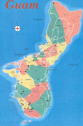

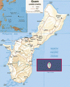

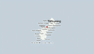
Country - Guam
 |
 |
People born on Guam are American citizens but are politically disenfranchised, having no vote in the United States presidential elections while residing on Guam. Guam delegates to the United States House of Representatives have no vote on the floor. Indigenous Guamanians are the Chamoru, historically known as the Chamorro, who are related to the Austronesian peoples of Malay archipelago, the Philippines, Taiwan, and Polynesia. But unlike most of its neighbors, Chamorro language is not classified as a Micronesian or Polynesian language. Rather, like Palauan, it possibly constitutes an independent branch of the Malayo-Polynesian language family. As of 2022, Guam's population is 168,801. Chamorros are the largest ethnic group, but a minority on the multi-ethnic island. The territory spans 210 mi2 and has a population density of 775 /mi2. The Chamorro people settled the island approximately 3,500 years ago. Portuguese explorer Ferdinand Magellan, while in the service of Spain, was the first European to visit the island on March 6, 1521. Guam was colonized by Spain in 1668. Between the 16th and 18th centuries, Guam was an important stopover for the Spanish Manila Galleons. During the Spanish–American War, the United States captured Guam on June 21, 1898. Under the 1898 Treaty of Paris, Spain ceded Guam to the U.S. effective April 11, 1899.
Currency / Language
| ISO | Currency | Symbol | Significant figures |
|---|---|---|---|
| USD | United States dollar | $ | 2 |
| ISO | Language |
|---|---|
| CH | Chamorro language |
| EN | English language |